A Louisiana Outbank Adventure Trip on the Creole Nature Trail
by Linda
Aksomitis
A
roseate spoonbill, feathers flapping, voice croaking, escaped
my camera. Small creatures rustled through the dried vegetation
unseen. Golden roseau cane towered six to seven feet above
the wetlands, like grass from Gulliver's land of the giants,
its stems thick as sugar cane, but tops hanging heavy with
grass seeds.
 |
|
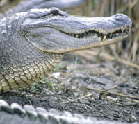
An
alligator Basking in the sunlight. |
A
few feet further the marsh was wetter, a squishy sponge oozing
mud and water. The sun beamed hot against the earth, much
hotter than the 65 degree air that kept my shirt sleeves rolled
down. I peered into the marsh, my eyes differentiating between
the different types of grass and cane, until I saw a lump,
a long scaly lump that ended in a tail. It didn't flinch,
twitch, wiggle.
I
wasn't expecting an alligator.
In
fact, I was expecting the area to be similar to the Louisiana
swamps I'd already visited and loved. I had a lot to learn
about marshes and the Creole Nature Trail in the southwest.
This part of the state is a full 18 feet above sea level,
rather than being below, like the area around New Orleans.
Often described as Louisiana's Outback, this area had lots
more surprises in store for me!
The
Creole Nature Trail was one of the first US designated scenic
highways, a term that means the highway is a tourist destination
in itself. In 2002 it received the All American Road designation.
The criteria for this title include possessing multiple intrinsic
qualities, such as cultural, historic, or natural character;
be nationally significant; and possess features that do not
exist elsewhere.
Over
the course of some 180 miles, the prairie melts into freshwater
marsh, which gradually merges into the Gulf of Mexico creating
brackish or salty marsh waters. I started my journey along
the trail east of Lake Charles, off of Interstate 10, at the
town of Sulphur on La 27 (the highway number for the trail),
which is one of the most popular stretches of the trail since
it is so easily accessible.
Centuries
ago, when Europeans first visited the area, it was home to
the Attakapas-their name coming from the Choctaw word for
"eaters of human flesh." While their somewhat cannibalistic
rituals during victory celebrations earned them a notorious
reputation, they were also known for their exceptional pottery
and mound building. Some folklorists credit this culture with
the origins of the term zydeco, which is the name of a type
of music popular down south as well as of the event at which
it is played, and it is also used to describe what people
do when they get there.
Through the years, many other tales of the land along the Creole Nature Trail became part of local lore. Some say the pirate Jean Lafitte hid his treasure in Kelso Bayou in Hackleberry. This tale was the inspiration for the celebration of Contraband Days in May, one of more than about 75 festivals held annually in southern Louisiana.
The Wetland Walkway, where I'd been up close and personal with a silent alligator in the marsh, is part of the Sabine National Wildlife Refuge. Its prime function is to preserve a large area of coastal wetlands for wintering and migrating waterfowl. The area is a stopover for two flight patterns across continental USA-the Mississippi and Central flyways. I found it amazing to gaze at birds I'd see in the not-to-distant future on Western Hemispheric Shorebird Reserve Network sites at home in Saskatchewan, several thousand miles north.
Also a major nursery for many estuarine-dependent marine species, the Sabine National Wildlife Refuge provides 124,511 acres of habitats varying between the four types of marshes: freshwater, intermediate, brackish, and salt water. Much shallower than swamps, the marsh areas abound in grasses that help stabilize the soil and avoid loss of land to erosion. The sun shining on the shallow water and mud provides a much warmer home for the alligator, so that rather than hiding out in a hole of thick mud, he comes out to sun himself throughout the winter season.
My hike at the Wetland Walkway also introduced me to a variety of intermediate marsh grasses that would be a jungle of vegetation during summer, but were a golden brown sea for my winter visit. These included the arrowhead, cordgrass, wiregrass, deer pea, water hyssop, and to me, amazing Roseau grass. The waters were full of life: brown shrimp, blue crab, gulf menhaden. My footsteps launched a flock of egrets into the sky, squawking their irritation.
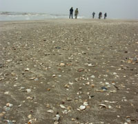 |
A veritable department store strewn across the sand offered up colorful shells, whelks, conch, sharkseye, angelwings and cockles. |
Journeying further along the Creole Nature Trail, Martin Beach opened up a whole new world of discovery. Waves lapped at the Gulf coast shore bringing with them a Santa's sack of surprises. A veritable department store strewn across the sand offered up colorful shells, whelks, conch, sharkseye, angelwings and cockles. Indeed an infant couldn't step on the beach without the crunch of crumbling treasures beneath his feet.
The most amazing find I made, however, was a large pod buried in the silky white sand. The seed pod, much to my surprise, came from the Amazon Rainforest and had drifted across the gulf. Dried brown strands of seaweed from the Caribbean's Sea of Sargasso rode in with the waves, like surfers in the sun, before being spread across the beach.
The Creole Nature Trail is home to several beaches along the Gulf of Mexico, locally known as the "Cajun Riviera." The white sands of Rutherford Beach conjured images of children building castles, teens tossing frisbies, and parents lounging in the sun-of course only a Canadian like me would think of such things when the temperature was in the mid-60s. I yearned to try walking this Cajun Riviera the thirty-odd miles right to Texas.
Nearly one-third of the population of the area along the trail, and in several other nearby parishes, are of Acadiana descent, or Cajuns. In fact, I had a great Cajun lunch along the route in the town of Cameron, at Stella's Restaurant. The crab cake appetizer was melt-in-your mouth delicious, while the gumbo was a great example of why Cajun cooking is a world-wide institution.
Leaving on the Cameron ferry, which crosses the Calcasieu Ship Channel connecting the Intracoastal Waterway to the Gulf, I was sad to think of the afternoon coming to an end. Tiny Cameron port is ranked around sixth in the nation in tons of seafood loaded annually. Indeed, my hands were itching to find some gear to pull in a supper of my own. The local favorite sport is catching crab onshore with a simple rod and string tied with bait, then netting the catch when it bites. Ah, I thought, what a way to spend the afternoon, never mind having a feast for the evening along with a nice big bowl of jambalaya, and pecan pie for dessert. Then I'd watch the sun drop over the Gulf of Mexico's sparkling waters and continue my way along the Creole Nature Trail, discovering more riches of Louisiana's Outback.
|