Visit Natural and Historical Sites Northern Alabama
by James Richardson
When
you think of the South, and particularly the State of Alabama,
the last thing to come to mind would probably be mountains.
However, in the northern section of Alabama a big surprise
awaits visitors who enter the state's borders. That surprise
is the presence of mountains. Granted, the mountains of Northern
Alabama are not huge by most anyone's scale, but nevertheless,
they are mountains. And along with its mountains, there are
waterfalls and other natural features that make encouraging
and exciting outdoor adventures for the visitor.
Northern
Alabama does not cover a lot of territory. The entire state
of Alabama at its widest point is close to two hundred miles
east to west and about three hundred fifteen miles north to
south. Its northern-most point is only about one hundred forty
miles across and broadens to around one hundred fifty-five
miles. This section is also only seventy miles from north
to south. All this means that in this small area there are
many attractions that visitors would enjoy and it does not
require extensive travel time.
A
Natural State
The
mountains of Northern Alabama are actually part of the foothills
of the Appalachian Plateau. The terrain of the western part
of this region is gently rolling hills. Farther eastward,
the hills make a transition into small mountains. The highest
point in Alabama is Cheaha Mountain at 2407 feet. It is located
near Anniston just south of Interstate 20 in Cheaha State
Park. In the more scenic and rugged eastern part of Alabama's
Mountain Lakes Region, the mountains have names like Gunter,
Sand, Blount, and Lookout Mountain. Along their crests hiking
trails abound. In their valleys, rivers create playgrounds
for water enthusiasts. Along their paths downward many beautiful
waterfalls are produced.
|
|
|
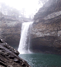
Majestic DeSoto Falls
Photo Credit: DeSoto State Park |
Paralleling
Interstate 59, the Lookout Mountain Parkway follows the crest
of Lookout Mountain for about one hundred miles. This scenic
drive passes through DeSoto State Park. There are fifteen
waterfalls within the park -- some large, some small. The
largest is DeSoto Falls, a one hundred-foot waterfall, in
the western section of the park along the West Fork of the
Little River. The falls is easily accessible and is just below
a dam and its resulting lake. From the entrance to DeSoto
Park, go east on County Road 89 to CR 513. Follow signs to
DeSoto Falls.
DeSoto Park adjoins the Little River Canyon Natural Preserve, which is maintained by the U.S. Department of the Interior. Within the preserve, the Canyon Rim Drive (Alabama State Route 176) follows the Little River Canyon for twenty-eight miles along the west rim. Overlooks into the canyon offer visitors glimpses of the exciting whitewater below. The Little River Falls mark the beginning of the canyon and, from the first two overlooks, the views of the falls are impressive. The first overlook is actually beside the falls on the east rim. Alabama State Route 35 leads visitors from Fort Payne. The Canyon Rim Drive (AL 176) is off AL 35 just before crossing the Little River. The first overlook to the waterfall is across the river off AL 35. There is a parking area with a brief walk to the overlook.
The western part of the state also has its braggable natural features -- rock canyons, natural arches, and lush forests. The Dismals Canyon is definitely not dismal. The Natural Bridge is definitely natural.
Dismals Canyon is located just off US Highway 43 on Franklin County Road 8. Near the town of Phil Campbell and south of Russellville, four miles south of the intersection of State Highway 13 and US 43, there is an eastward turnoff onto Franklin County Road 8. Go one mile to the entrance to Dismals Canyon.
It is believed that the dark, misty canyon got its dreary name from Scotch-Irish settlers. Known for its colorful history of secret Indian rituals and as a hideout for outlaws, Dismals Canyon was also the holding ground for some of the Cherokee and Chickasaw Indians prior to the Trail of Tears. Within the area's boundaries is one of the oldest stands of forest east of the Mississippi River. Waterfalls, rock formations, cliffs and natural bridges are also features in Dismals Canyon. Night tours are conducted during the summer to see the glow-in-the-dark worms known as "Dismalites," which are seen on moss-covered boulders in the canyon. This is the only known location in the United States to see these night creatures. Other known locations are China and New Zealand.
Just east of the William B. Bankhead National Forest is Natural Bridge, the town and its accompanying 148 foot long, sixty-foot high, and eight foot thick sandstone "natural bridge." Within a forested setting, hiking trails lead under and around the impressive formations. The Natural Bridge of Alabama is located on US Highway 278 in Marion County.
The Tennessee River dips down into Alabama long enough to offer opportunities for water recreation and, with the help of the Tennessee Valley Authority (which built hydroelectric dams at three locations along the river) there are large lakes for even more occasions for water enjoyment. Dams along the Tennessee River form Pickwick, Wilson, Wheeler, and Guntersville Lakes.
At all the lakes along the Tennessee River fishing and boating can be enjoyed. The largest lake in Northern Alabama, Lake Guntersville, contains 69,000 acres of surface area and over nine hundred miles of shoreline and is known for its excellent bass populations. At Lake Guntersville State Park, camping facilities, a restaurant and lodge, a golf course and tennis courts, and a beach area are all available for the visitor. Stop at Mabrey's Overlook near the entrance to the golf course for a spectacular sunset over Lake Guntersville. To get to Lake Guntersville State Park, take State Highway 227 east out of Guntersville. The public park is located six miles northeast.
An Unnatural State
In Northern Alabama there are many manmade attractions worthy of consideration also. Of the twelve covered bridges in Alabama, six are in the Alabama Mountain Lakes Region. Three of those are near the towns of Cleveland and Oneonta in the south-central part of the region. The Swann, the Horton Mill, and the Old Easley Road Covered Bridges are all in Blount County and would make interesting side trips.
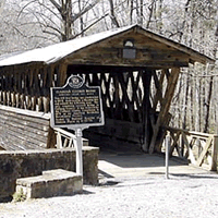
|
Historic Clarkson Bridge
Photo Credit: Cullman County P&R |
Another covered bridge in the vicinity is the Clarkson Covered Bridge along US 278 between the Bankhead National Forest and Cullman. The Clarkson is also known as the Legg Covered Bridge. It is 270 feet long and was built in 1904. In 1921 the Clarkson Bridge was destroyed by a flood, but was rebuilt the following year. The picnic tables beneath it make for an enjoyable break in traveling.
The cities of Northern Alabama have historical and cultural attractions for the visitor that wants to diversify his adventures. Huntsville is most famous for the United States Space and Rocket Center with its popular Space Camp. The large museum includes a full-sized space shuttle, a Saturn V rocket, and an actual Apollo 16 capsule. There is even a moon rock. Several other museums are located in Huntsville along with a botanical garden.
Decatur, situated on the Tennessee River's Wheeler Lake, has a colorful history dating back to 1823, when it was founded honoring Commodore Stephen Decatur.
During the Civil War, it was the site of many skirmishes due to its strategic location. As a result, only four buildings were left standing after 1865. The historic district of Decatur comprises an area of 118 acres with buildings dating from as early as 1870.
Other attractions in the region include the Renaissance Tower and Aquarium, which rises three hundred feet above Lake Wilson. The aquarium, near Florence, contains sixty-two tanks with representative specimen from around the world. Also in Florence, the W.C. Handy Birthplace and Museum and Pope's Tavern, which was used in the nineteenth century as a stagecoach inn and during the Civil War as a military hospital.
Summary
Finding something to do in Northern Alabama will be no problem for the visitor. From the east to the west, the guidebooks are full of opportunities for overnight stops or entire vacation stays. The scenery and attractions of the Alabama Mountains Lakes region make Northern Alabama a surprising and welcome destination
for travelers.
IF YOU GO... |
Decatur Convention and Visitors Bureau
E-mail: info@decaturcvb.org
www.decaturcvb.org
Huntsville/Madison County Convention and Visitors Bureau
E-mail: info@huntsville.org
(800) SPACE-4U
www.huntsville.org
Lake Guntersville Chamber of Commerce
E-mail: gcc@localaccess.net
(800) 869-LAKE
www.lakeguntersville.org
Other information:
Dismals Canyon
(205) 993-4559
Hours of operation:
Memorial Day to Labor Day: Daily 10 a.m. to 6 p.m.
Night tours: Friday and Saturday at 9 p.m.
Labor Day to Memorial Day: Friday - Sunday 10 a.m. to 5 p.m.
Admission - Adults $5.00; Children $3.00 |
|